1•Plate Tectonics, their cause
2•Seismic Waves from earthquakes
3•What is Richter Magnitude?
4•Earthquake Intensities
1.Plate Tectonics, the Cause of Earthquakes
Only lithosphere has the strength and the brittle behavior to fracture in an earthquake.
The plates consist of an outer layer of the Earth, the lithosphere, which is cool enough to behave as a more or less rigid shell. Occasionally the hot asthenosphere of the Earth finds a weak place in the lithosphere to rise buoyantly as a plume, or hotspot. The satellite image below shows the volcanic islands of the Galapagos hotspot.
Earthquake occurrence in different plate tectonic settings:
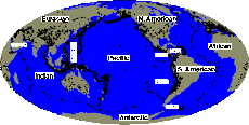
The map below of Earth's solid surface shows many of the features caused by plate tectonics. The oceanic ridges are the asthenospheric spreading centers, creating new oceanic crust. Subduction zones appear as deep oceanic trenches. Most of the continental mountain belts occur where plates are pressing against one another. The white squares locate examples given here of the different tectonic and earthquake environments.
2.Seismic Deformation
When an earthquake fault ruptures, it causes two types of deformation: static; and dynamic. Static deformation is the permanent displacement of the ground due to the event. The earthquake cycle progresses from a fault that is not under stress, to a stressed fault as the plate tectonic motions driving the fault slowly proceed, to rupture during an earthquake and a newly-relaxed but deformed state.
Typically, someone will build a straight reference line such as a road, railroad, pole line, or fence line across the fault while it is in the pre-rupture stressed state. After the earthquake, the formerly stright line is distorted into a shape having increasing displacement near the fault, a process known as elastic rebound.
Seismic Waves
The second type of deformation, dynamic motions, are essentially sound waves radiated from the earthquake as it ruptures. While most of the plate-tectonic energy driving fault ruptures is taken up by static deformation, up to 10% may dissipate immediately in the form of seismic waves.
The mechanical properties of the rocks that seismic waves travel through quickly organize the waves into two types. Compressional waves, also known as primary or P waves, travel fastest, at speeds between 1.5 and 8 kilometers per second in the Earth's crust. Shear waves, also known as secondary or S waves, travel more slowly, usually at 60% to 70% of the speed of P waves.
P waves shake the ground in the direction they are propagating, while S waves shake perpendicularly or transverse to the direction of propagation.
Although wave speeds vary by a factor of ten or more in the Earth, the ratio between the average speeds of a P wave and of its following S wave is quite constant. This fact enables seismologists to simply time the delay between the arrival of the P wave and the arrival of the S wave to get a quick and reasonably accurate estimate of the distance of the earthquake from the observation station. Just multiply the S-minus-P (S-P) time, in seconds, by the factor 8 km/s to get the approximate distance in kilometers.
The dynamic, transient seismic waves from any substantial earthquake will propagate all around and entirely through the Earth. Given a sensitive enough detector, it is possible to record the seismic waves from even minor events occurring anywhere in the world at any other location on the globe. Nuclear test-ban treaties in effect today rely on our ability to detect a nuclear explosion anywhere equivalent to an earthquake as small as Richter Magnitude 3.5.
src="http://pagead2.googlesyndication.com/pagead/show_ads.js">
Seismographs and Seismograms
Sensitive seismographs are the principal tool of scientists who study earthquakes. Thousands of seismograph stations are in operation throughout the world, and instruments have been transported to the Moon, Mars, and Venus. Fundamentally, a seismograph is a simple pendulum. When the ground shakes, the base and frame of the instrument move with it, but intertia keeps the pendulum bob in place. It will then appear to move, relative to the shaking ground. As it moves it records the pendulum displacements as they change with time, tracing out a record called a seismogram.
One seismograph station, having three different pendulums sensitive to the north-south, east-west, and vertical motions of the ground, will record seismograms that allow scientists to estimate the distance, direction, Richter Magnitude, and type of faulting of the earthquake. Seismologists use networks of seismograph stations to determine the location of an earthquake, and better estimate its other parameters. It is often revealing to examine seismograms recorded at a range of distances from an earthquake:
3.What is Richter Magnitude?
Short answer:
Seismologists use a Magnitude scale to express the seismic energy released by each earthquake. Here are the typical effects of earthquakes in various magnitude ranges:
Earthquake Severity
Richter Earthquake
Magnitudes Effects
Less than 3.5 Generally not felt, but recorded.
3.5-5.4 Often felt, but rarely causes damage.
Under 6.0 At most slight damage to well-designed buildings.
Can cause major damage to poorly constructed buildings
over small regions.
6.1-6.9 Can be destructive in areas up to about 100 kilometers
across where people live.
7.0-7.9 Major earthquake. Can cause serious damage over larger areas.
8 or greater Great earthquake. Can cause serious damage in areas several
hundred kilometers across.
Although each earthquake has a unique Magnitude, its effects will vary greatly according to distance, ground conditions, construction standards, and other factors. Seismologists use a different Mercalli Intensity Scale to express the variable effects of an earthquake.
Each earthquake has a unique amount of energy, but magnitude values given by different seismological observatories for an event may vary. Depending on the size, nature, and location of an earthquake, seismologists use several different methods to estimate magnitude. The uncertainty in an estimate of the magnitude is about plus or minus 0.3 units, and seismologists often revise magnitude estimates as they obtain and analyze additional data.
B.FAQs
- Current Earthquake Information
•Can I get on a list to receive an e-mail message when there is an earthquake?
•How can I report an earthquake experience or related observation?
•Where can I see current or past seismograms?
•How do I find what I want?
•What pages should I bookmark?
•Why are squares used for the earthquakes?
•How were the symbol sizes chosen?
•How were the colors chosen?
•Why do so many earthquakes occur at a depth of 10km?
•What do "last hour", "last day" and "last week" mean?
•How do the earthquakes get to the webpages?
•Why do some earthquakes disappear?
•Why isn't the distance to the nearest fault provided?
•How did you decide which places to use for computing the distance to individual earthquakes?
•What is the reference point for the places?
•How did you decide which places to plot on the maps?
•How fast does the earthquake information get posted to the web site, get sent out via the Earthquake Notification Serice (ENS), RSS feeds, etc?
Q: How can I report an earthquake experience or related observation?
A: The Community Internet Intensity Maphttp://earthquake.usgs.gov/earthquakes/dyfi/
Measuring Earthquakes
•Where can I buy a Richter scale?
•Why are there often different magnitudes reported for the same earthquake?
•What is moment magnitude?
•What are the earthquake magnitude classes?
•When was the first instrument that actually recorded an earthquake?
•What is a P wave? An S wave?
•What does an earthquake look like?
•What is intensity? What is the Modified Mercalli Intensity Scale?
•What is the difference between intensity scales and magnitude scales?
•What is acceleration, velocity, and displacement?
•What is spectral acceleration?
•What are those beachball figures?
•How much energy is released in an earthquake?
•What are UTC and GMT (in reference to the time of an EQ)?
•What does it mean that the earthquake occurred at a depth of 0 km?
•How are earthquakes recorded? How are earthquakes measured? How is the magnitude of an earthquake determined?
•What are the different magnitude scales, and why are there so many?
•How do you give a Richter magnitude to earthquakes that occurred prior to the scale?
•What was the duration of the earthquake? Why don't you report the duration of each earthquake? How does the duration affect the magnitude?
•How do seismologists locate an earthquake?
More Information on Measuring Earthquakes
•Magnitudes
•Intensity
When an Earthquake Strikes Preparing Your Family and Home Preparing Your Workplace
More Information on Earthquakes Commercial Suppliers of
 Earthquake Safety Products
When an Earthquake Strikes
•Safety tips! Look, duck, cover, and hold! (gif)
•Tips to treat injuries (gif)
•Felt an Earthquake? Report It
◦About the USGS Community Internet Intensity Map
◦Report in more detail on Nevada or historical earthquakes
Preparing Your Family and Home
•Individual and family preparedness measures for the first 72 hours (gif)
•Reducing home hazards (gif)
•Strap the water heater (gif)
•Automatic earthquake gas shut-off valves (gif)
•Make a family earthquake plan (gif)
•Personal medical plan (gif)
•Earthquake survival in a can (gif)
•Emergency food supply (gif)
Preparing Your Workplace
•Keep books and binders in place during an earthquake (gif)
•Secure your computer equipment against earthquake damage (gif)
The death toll from Chile's 8.8 magnitude earthquake looks like being a fraction of the 220,000 people who were killed in Haiti in January.
This is despite the Chilean quake being 500 times stronger than the one in Haiti.
Clearly, Chile is a more prosperous country, with economic output per head of the population more than 10 times greater than Haiti.
That has meant that buildings in general are better built, but Chile was also better prepared.
People in Chile knew the safest places to go to when the earthquake struck.
Also, since an even stronger earthquake in 1960, Chile has developed a seismic design code for new buildings, which has made them better able to stay standing in an earthquake.
One system that helps buildings stay up is called the "strong columns weak beams" system.
The idea is that buildings are held up by reinforced concrete columns, which are strengthened by a steel frame.
Reinforced concrete beams are joined onto the columns to make floors and the roof.
If there is an earthquake, the idea is that the concrete on the beams should break near the end, which dissipates a lot of the energy of the earthquake, but that the steel reinforcement should survive and the columns should stay standing, which means the building will stay upright.
The problem is that an 8.8 magnitude earthquake is "towards the top end of what you're designing for", according to Professor Colin Taylor, professor of earthquake engineering at Bristol University.
Another advantage for the Chilean quake was that its epicentre was 21 miles (34km) underground, off-shore and 70 miles (115km) from the nearest big city, Concepcion.
The energy from earthquakes falls the further away you are from the centre.
The Haitian quake on the other hand was only 8 miles (13km) underground and right on the edge of Port-au-Prince.
C.LATEST EARTHQUAKES
Magnitude 8.8 OFFSHORE MAULE, CHILE February 27, 2010
•Magnitude 7.0 RYUKYU ISLANDS, JAPAN February 26, 2010
•Magnitude 6.9 CHINA-RUSSIA-NORTH KOREA BORDER REGION February 18, 2010
•Magnitude 5.9 OFFSHORE NORTHERN CALIFORNIA February 04, 2010
•Magnitude 7.0 HAITI REGION January 12, 2010
2009
Magnitude 5.9 BAJA CALIFORNIA, MEXICO December 30, 2009
•Magnitude 6.4 TAIWAN December 19, 2009
•Magnitude 6.8 TONGA November 24, 2009
•Magnitude 6.6 QUEEN CHARLOTTE ISLANDS REGION November 17, 2009
•Magnitude 6.5 OFFSHORE TARAPACA, CHILE November 13, 2009
•Magnitude 7.3 FIJI November 09, 2009
•Magnitude 6.6 SUMBAWA REGION, INDONESIA November 08, 2009
•Magnitude 6.8 RYUKYU ISLANDS, JAPAN October 30, 2009
•Magnitude 6.2 HINDU KUSH REGION, AFGHANISTAN October 29, 2009
•Magnitude 6.9 BANDA SEA October 24, 2009
•Magnitude 6.1 SUNDA STRAIT, INDONESIA October 16, 2009
•Magnitude 5.9 SANTA CRUZ ISLANDS October 08, 2009
•Magnitude 6.8 VANUATU October 08, 2009
•Magnitude 6.6 SANTA CRUZ ISLANDS October 08, 2009
•Magnitude 7.4 VANUATU October 07, 2009
•Magnitude 7.8 SANTA CRUZ ISLANDS October 07, 2009
•Magnitude 7.7 VANUATU October 07, 2009
•Magnitude 6.8 CELEBES SEA October 07, 2009
•Magnitude 6.6 MORO GULF, MINDANAO, PHILIPPINES October 04, 2009
•2009 Olancha, CA Earthquake Sequence (updated)
•Magnitude 6.6 SOUTHERN SUMATRA, INDONESIA October 01, 2009
•Magnitude 7.5 SOUTHERN SUMATRA, INDONESIA September 30, 2009
•Magnitude 8.1 SAMOA ISLANDS REGION September 29, 2009
•Magnitude 6.1 BHUTAN September 21, 2009
•Magnitude 6.3 OFFSHORE CARABOBO, VENEZUELA September 12, 2009
•Magnitude 5.5 ALBANIA September 06, 2009
•Magnitude 7.0 JAVA, INDONESIA September 02, 2009
•Magnitude 6.6 SAMOA ISLANDS REGION August 30, 2009
•Magnitude 6.2 NORTHERN QINGHAI, CHINA August 28, 2009
•Magnitude 6.9 BANDA SEA August 28, 2009
•Magnitude 3.7 COLORADO August 18, 2009
•Magnitude 6.7 SOUTHWESTERN RYUKYU ISLANDS, JAPAN August 17, 2009
•Magnitude 6.7 KEPULAUAN MENTAWAI REGION, INDONESIA August 16, 2009
•Magnitude 6.6 IZU ISLANDS, JAPAN REGION August 12, 2009
•Magnitude 6.1 NEAR THE SOUTH COAST OF HONSHU, JAPAN August 10, 2009
•Magnitude 7.5 ANDAMAN ISLANDS, INDIA REGION August 10, 2009
•Magnitude 6.6 SANTA CRUZ ISLANDS August 10, 2009
•Magnitude 7.1 NEAR THE SOUTH COAST OF HONSHU, JAPAN August 09, 2009
•Magnitude 6.9 GULF OF CALIFORNIA August 03, 2009
•Magnitude 7.8 OFF WEST COAST OF THE SOUTH ISLAND, N.Z. July 15, 2009
•Magnitude 5.7 YUNNAN, CHINA July 09, 2009
•Magnitude 6.4 CRETE, GREECE July 01, 2009
•Magnitude 6.7 NEW IRELAND REGION, PAPUA NEW GUINEA June 23, 2009
•Magnitude 3.5 SAN FRANCISCO BAY AREA, CALIFORNIA June 08, 2009
•Magnitude 6.3 VANUATU June 02, 2009
•Magnitude 7.3 OFFSHORE HONDURAS May 28, 2009
•Magnitude 4.7 NORTH KOREA May 25, 2009 (presumed nuclear test)
•Magnitude 4.7 GREATER LOS ANGELES AREA, CALIFORNIA May 18, 2009
•Magnitude 6.5 KERMADEC ISLANDS REGION May 16, 2009
•Magnitude 3.5 NORTHERN CALIFORNIA April 30, 2009
•Magnitude 6.6 KURIL ISLANDS April 18, 2009
•Magnitude 6.7 SOUTH SANDWICH ISLANDS REGION April 16, 2009
•Magnitude 5.2 ISLAND OF HAWAII, HAWAII April 14, 2009
•Magnitude 6.9 KURIL ISLANDS April 07, 2009
•Magnitude 6.3 CENTRAL ITALY April 06, 2009
•Magnitude 4.8 SOUTHERN CALIFORNIA March 24, 2009
•Magnitude 4.3 NORTHERN CALIFORNIA March 30, 2009
•Magnitude 7.6 TONGA REGION March 19, 2009
•Magnitude 3.5 SAN FRANCISCO BAY AREA, CALIFORNIA March 08, 2009
•Magnitude 7.0 KERMADEC ISLANDS REGION February 18, 2009
•Magnitude 7.2 KEPULAUAN TALAUD, INDONESIA February 11, 2009
•Magnitude 3.0 GREATER NEW YORK AREA, NEW JERSEY February 03, 2009
•Magnitude 4.5 SEATTLE-TACOMA URBAN AREA, WASHINGTON January 30, 2009
•Magnitude MW 5.8 SOUTHERN ALASKA January 24, 2009
•Magnitude 6.6 SOUTHEAST OF THE LOYALTY ISLANDS January 19, 2009
•Magnitude 6.4 KERMADEC ISLANDS, NEW ZEALAND January 18, 2009
•Magnitude 7.4 EAST OF THE KURIL ISLANDS January 15, 2009
•Magnitude 6.7 SOUTHEAST OF THE LOYALTY ISLANDS January 15, 2009
•Magnitude 4.5 GREATER LOS ANGELES AREA, CALIFORNIA January 09, 2009
•Magnitude 6.1 COSTA RICA January 08, 2009
•Magnitude 7.4 NEAR THE NORTH COAST OF PAPUA, INDONESIA January 03, 2009
•Magnitude 7.7 NEAR THE NORTH COAST OF PAPUA, INDONESIA January 03, 2009
VERY LATEST
CHILE EARTHQUAKE
_svg.png)
Chile earthquake: Pacific nations brace for tsunamiIslands evacuate coastal areas as Chilean president declares state of catastrophe after deadly quake of magnitude 8.8
Tweet this
David Batty and agencies guardian.co.uk, Saturday 27 February 2010 16.04 GMT Article history
A collapsed highway near Santiago after an earthquake hit Chile. Photograph: David Lillo/AP
A wide array of Pacific nations, including the US, Australia, the Phillipines to Japan, are bracing for potentially devastating tidal waves after a massive earthquake in Chile triggered a tsunami which is radiating across the ocean.
The quake, with a magnitude of 8.8, has already killed at least 120 people in mainland Chile and prompted the evacuation of coastal areas on Easter Island – famous for its monumental stone statues – as well as Samoa and American Samoa.
Michelle Bachelet, the outgoing Chilean president, declared a "state of catastrophe" in central Chile and said a huge tidal wave had swept into the Juan Fernandez Islands. Local radio stations reported serious damage on the archipelago, which reputedly inspired the novel Robinson Crusoe.
By MarketWatch
SAN FRANCISCO An 8.8-magnitude earthquake, the fifth most severe in more than a century, struck Chile early Saturday, killing at least 300 people, collapsing structures and throwing the South American country into turmoil.
Devastation after Earthquake in ChileRescuers are scouring the damage for survivors but aftershocks and debris are slowing them down. Video courtesy of Reuters.
Chilean President Michelle Bachelet said the country had been thrown into a "state of catastrophe." She said the quake had affected at least 80% of the country's population of 16 million.
She asked the country's citizens to use water, electricity and fuel carefully and was quoted by The Wall Street Journal as saying the government was "trying by every means possible to bring the country back to normal."
President Obama said the U.S. stood ready to assist Chile and reports said the European Union was preparing $4 million of immediate aid to the country.
Carmen Fernandez, head of the country's National Emergency Agency, was quoted by the Associated Press as saying that more than 300 may have died and that figure will grow. Reports said the death toll may be lower than it might otherwise have been because the country had enacted strict building codes after previous earthquakes.
Television images showed scenes of extensive devastation. Buildings and bridges were collapsed, fires burned and cars were shown lying upside down amid the wreckage of overpasses and other structures. Telecommunications services and other utilities were significantly disrupted.
The quake struck just six weeks after a magnitude-7 temblor hit the Caribbean island nation of Haiti, killing about 200,000 people and devastating much of the country, which is the poorest in the Western Hemisphere. The country is still struggling to return to normal.
Japan on Sunday had its entire eastern coastline on alert and ordered hundreds of thousands of people in low-lying areas to find higher ground, . The first reverberating waves to hit Japan arrived Sunday; they were small but officials said a bigger surge could follow, Japan is about 10,700 miles from Chile and 4,000 miles from Hawaii.
Russia canceled a tsunami warning after waves that hit the Kamchatka peninsula proved not to be dangerous, Fox News reported, quoting RIA Novosti news agency
A tsunami triggered by the earthquake swept through the Hawaiian archipelago at about 7 p.m. Eastern Time, doing no damage and easing fears that the U.S. West Coast might be at risk. The tsunami warning in effect in Hawaii was canceled shortly after 7 p.m. Eastern, according to reports.
Earlier, tsunami warnings had been issued for 50 countries and territories across thousands of miles of the Pacific Rim after the quake.
The earthquake off the Chilean coast, the fifth-greatest-magnitude quake globally since 1900, struck Chile, the world's largest copper producer, at 1:34 a.m. Eastern Time Saturday and lasted more than a minute. It was Chile's worst earthquake in 50 years, since a 9.5 quake, the largest recorded quake in history, struck off Chile's coast in roughly the same area.
LATEST EARTHQUAKES
Significant Earthquakes
M 8.8 Offshore Maule, Chile February 27, 2010 06:34:17 UTCM 7.0 Ryukyu Islands, Japan February 26, 2010 20:31:26 UTCM 6.9 China-russia-north Korea Border Region February 18, 2010 01:13:17 UTCM 5.9 Offshore Northern California February 4, 2010 20:20:21 UTCM 7.0 Haiti Region January 12, 2010 21:53:09 UTCAll Significant Earthquakes
Recent Earthquakes (M 2.5+)
M 6.4, Vanuatu
March 4, 2010 14:02:30 UTC
M 2.5, Southern Alaska
March 4, 2010 13:27:27 UTC
M 4.8, Near The North Coast Of Papua, Indonesia
March 4, 2010 12:57:21 UTC
M 3.9, Offshore Northern California
March 4, 2010 12:22:31 UTC
M 5.1, Mendoza, Argentina
March 4, 2010 10:53:51 UTC
Earthquake News
Strong earthquake hits Taiwan; 64 people injured
5 hrs ago - A powerful 6.4-magnitude earthquake rocked southern Taiwan on Thursday, terrifying residents, disrupting communications and triggering at least one large fire. Sixty-four people were injured.
Powerful 6.4-magnitude earthquake rocked southern Taiwan on Thursday, terrifying residents, disrupting communications and triggering at least one large fire. Sixty-four people were injured.
No tsunami alert was issued. The quake was centered in the same mountainous region of rural Kaohsiung county that endured the brunt of the damage from Typhoon Morakot, a devastating storm that killed about 700 people last August.
Taiwanese actor Chu Chung-heng said he and other passengers were close to panic when the high-speed train on which they were traveling was dislodged from its track by the quake.
Strong aftershock hits Chile quake zone
A strong aftershock with a preliminary magnitude of 6.3 has struck Chile's quake-stricken city of Concepcion, sending people running into the streets.
The U.S. Geological Survey says the aftershock hit at 6:19 a.m. (0939 GMT, 4:19 a.m. EST) Friday. People in Concepcion, ran out of buildings in their nightclothes.
Dozens of aftershocks have been recorded in Chile since Saturday's 8.8-magnitude quake.
Chile military rolls out post-quake aid effort
The Chilean military's humanitarian aid effort hit the streets, carrying food and water to some areas that had seen little of either since a mammoth earthquake struck five days ago.
Soldiers filled trucks with plastic bags of cooking oil, flour and canned beans, and municipal crews delivered the packages Wednesday to areas secured by troops from looters. The humanitarian role for Chile's army marked a shift for a military long associated with dictatorship-era repression.
Survivors cheered the troops' arrival and the restoration of order in streets still littered with rubble, downed power lines and destroyed cars. But some criticized that the first place in Concepcion to get an aid delivery was a street of houses inhabited by military families.
This entire block belongs to the army, Yanira Cifuentes, 31, said of the houses on General Novoa Avenue. She said her husband is an officer.
How did animals fare in the Chilean earthquakes?
when an 8.8 magnitude earthquake struck on February 28, 2010. Since then, as late as March 4, after shocks, actually earthquakes too with a magnitude of 6.6, have sent people running from buildings in those same towns and cities.
Cats and dogs sleeping in houses if they are lucky, and in doorways or under bridges if not as fortunate. No the dogs are not as spoiled in Argentina and Chile as they are in the U.S., but it is obvious that even the "Tramps" of the streets are loved by the people, and are taken care of by them.
Animal welfare organizations have the same worries and are readying to help the dogs and cats that are roaming the streets of the Chilean towns and cities, those who had a home previously, now joining the homeless. We have seen photos of dogs being rescued from demolished buildings. People don't have time for the animals when human life is at stake, even if they want to be kind and generous.
But what about the wildlife: the birds, sea lions, and penguins that so many people on our cruise ship had come thousands of miles to observe? We had learned for example, that the life of a penguin is a hard life. Predatory birds on land will steal their eggs and hatchlings, while in the water, neighboring sea lions will snatch a penguin for its own meal. Torrential rains can flood the penguins' nests and drown the eggs and hatchlings that have been protected there. And oil slicks and long voyages in the sea amidst a growing number of seafaring vessels, take many more.